Our involvements in the real estate industry include buying, selling and management of commercial or residential properties for our local and international clients. We also offer allied services such as location and title verification; power of attorney preparation; deed preparation; etc to facilitate successful property deals.
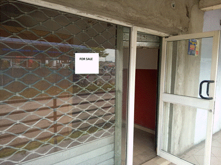
FOR SALE
N9.1M Asking
Description: Fenced with gate; and having a security house.
Proximity: 2-3 minutes drive from Artillary or Happy Bite/Airforce base.
Documents: Lease Hold Agreement for 10-13 years, depending on the transaction date and allied circumstances.
Recommended for: Office space, Lockup shop, and allied.
INFORMATICS: We offer services that involve non-spatial data processing, storage, retrieval and analysis using statistical and machine learning methods.
These include machine learning time series predictions using relatively sparse and big datasets.
GEOIFORMATICS: We offer geo-spatial data processing, storage, retrieval and analysis as a service using spatial statistics and machine learning methods. Geoinformatics is a multidisciplinary field of science that uses contemporary technologies
supporting the processes of measuring, acquiring, analyzing, and visualizing geospatial data. Consequently, we exploit the robust capabilities of remote sensing, GIS and GNSS (including RTK) applications to provide solutions to any location based problems,
particularly including the ones that are related to the impacts of climate change such as flood mapping, vegetation health mapping, environmental pollution mapping, deforestation mapping, landuse/landcover analysis, analysis of sea level anomalies in coastal areas,
probability of upstream seawater intrusion, assessment and prediction of sea surface salinity along coastal zones, mapping of sea surface variables (e.g. temperature and wind speed) along coastal zones, and so on.
We sell and lease house boats of various sizes, which include 40-man, 60-man, 100-man, etc. Please, contact us whenever you want to buy or sell or lease house boat.
We offer tanker vessels of different capacities from 1,000 metric tons and above for charter. We also sell working and scrapped vessels. Click the "Contact Us" button to reach us.
We sell and lease functional and scrapped barges (either self-propelled or ramp or dump) of different capacities from 1,000 metric tons and above.
SURVEYING
Deploying man power and Total Station of the highest level of accuracy to determine topography at any specified intervals for various applications.
Aquiring and analysing inundation datasets to determine floodwater level and extent for floodplains to produce flood maps to support projects and decisions.
Sampling water depth at fine spatial resolution using echosounder with dual frequency Global Navigation Satellite System to produce bathymetric maps.
Deploying drones (UAV) of both mapping and surveying grades to support different types of engineering and environmental projects in inaccessible areas.
In 2019, one of our above featured clients desired to have a decision support tool to determine the most approriate location for establishing a factory on a predominantly forested floodplain along the R. Niger in the Niger Delta; within stringent time-frame and financial budget. To meet the need after the client was referred to us by another happy client of ours; we used remotely sensed elevation dataset to augment the field topographic dataset for the inaccessible parts of our client's area of interest in order to save time and finacial cost by about 40% of the contract sum. This was achieved without compromising the required accuracy level for the project.
In 2014, Geo Inheritance Limited needed a new platform for the applications of geospatial techniques to support community policing effort in Nigeria. We initiated and led the execution of the initiative to enhance community policing in Nigeria using integrated Geospatial techniques (Web-GIS mapping, GNSS, cellular network and Google Earth imagery) using the city of Port Harcourt in Rivers State as a pilot project. We trained, mobilize and managed selected Nigerian Police Force officers on response to distress call using the innovative integrated Geospatial techniques. The pilot project was successful.
In 2010, in order to provide geospatial support for a wetland study and develoment project in an academic community; our team planned and led the logistics for the field work, which involved using an Echo-sounder with dual frequency GPS for bathymetric survey on a freshwater reservoir; GIS database/map creation using ArcGIS; geospatial data analysis; and took innovative steps to reduced the cost of map-data acquisition by about 4, 000 Canadian Dollar. Our client was happy that we lucratively delivered the projects within the incredible deadline.
FOLLOW US!